
Make a donation
Gear up for your next adventure:
As an Amazon Associate, this site earns from qualifying purchases at no extra cost to you.
Cherwell District topographic map
Click on the map to display elevation.
Make a donation
Gear up for your next adventure:
As an Amazon Associate, this site earns from qualifying purchases at no extra cost to you.
About this map
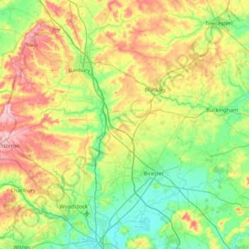
Name: Cherwell District topographic map, elevation, terrain.
Location: Cherwell District, Oxfordshire, England, United Kingdom (51.78096 -1.52284 52.16847 -1.04714)
Average elevation: 116 m
Minimum elevation: 56 m
Maximum elevation: 240 m
Make a donation
Gear up for your next adventure:
As an Amazon Associate, this site earns from qualifying purchases at no extra cost to you.
Other topographic maps
Click on a map to view its topography, its elevation and its terrain.
Juniper Hill
United Kingdom > England > Oxfordshire > Cherwell District > Cottisford
Average elevation: 126 m
Roke
United Kingdom > England > Oxfordshire > South Oxfordshire > Berrick Salome
Average elevation: 69 m
Make a donation
Gear up for your next adventure:
As an Amazon Associate, this site earns from qualifying purchases at no extra cost to you.