Geolocate

A Rabadeira topographic map

Click on the map to display elevation.

About this map

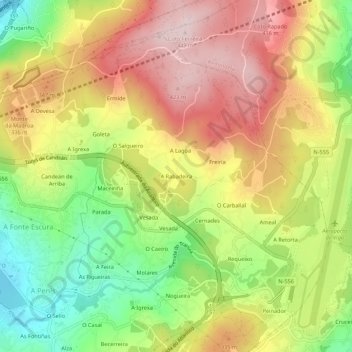
Name: A Rabadeira topographic map, elevation, terrain.

Location: A Rabadeira, Candeán, Vigo, Pontevedra, Galicia, 36318, España (42.21822 -8.67050 42.25822 -8.63050)

Average elevation: 267 m

Minimum elevation: 92 m

Maximum elevation: 432 m

Other topographic maps

Click on a map to view its topography, its elevation and its terrain.

Islas Cíes

España > Galicia > Vigo > Vigo

Average elevation: 3 m

Navia

España > Galicia > Vigo > Vigo

Average elevation: 20 m

Zamáns

España > Galicia > Vigo > Vigo

Average elevation: 397 m

Beade

España > Galicia > Vigo > Vigo

Average elevation: 187 m

Sárdoma

España > Galicia > Vigo > Vigo

Average elevation: 64 m

Illas Cíes

España > Galicia > Vigo > Vigo

Average elevation: 3 m

Coruxo

España > Galicia > Vigo > Vigo

Average elevation: 129 m

Candeán

España > Galicia > Vigo > Vigo

Average elevation: 266 m

Candeán

España > Galicia > Vigo > Vigo

Average elevation: 240 m

Gear up for your next adventure:

🔋Emergency Crank Radio - Weather alerts and power without needing batteries
🥾Waterproof Trail Shoes - Shoes designed to handle wet terrain
🔥Emergency Fire Starter - Reliable ignition source for all weather conditions
Family Camping Tent - Spacious tent suitable for family camping trips
🛶Kayak Dry Bag - Waterproof storage for kayaking adventures

As an Amazon Associate, this site earns from qualifying purchases at no extra cost to you.