Geolocate

Snells Beach topographic map

Click on the map to display elevation.

About this map

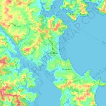
Name: Snells Beach topographic map, elevation, terrain.

Location: Snells Beach, Rodney, Auckland, 0920, New Zealand (-36.46048 174.68398 -36.38048 174.76398)

Average elevation: 27 m

Minimum elevation: -1 m

Maximum elevation: 120 m

Other topographic maps

Click on a map to view its topography, its elevation and its terrain.

Helensville

New Zealand > Auckland > Rodney

Average elevation: 21 m

Dome Forest

New Zealand > Auckland > Rodney

Average elevation: 168 m

Cowan Bay

New Zealand > Auckland > Rodney > Snells Beach

Average elevation: 22 m

Lake Rototoa

New Zealand > Auckland > Rodney

Average elevation: 102 m

Taupaki Estate

New Zealand > Auckland > Rodney > Kumeū

Average elevation: 37 m

Omaha Beach

New Zealand > Auckland > Rodney > Omaha

Average elevation: 3 m

Gear up for your next adventure:

🥾Mountain Hiking Boots - High-traction boots for rocky terrain
🔭Compact Monocular - One-handed bird watching and trail spotting
🧴Bear Spray Holster - Quick-access carry for essential Canadian wilderness safety
🐕Hiking Dog Pack - Let your canine companion carry their own water and food
🧥Packable Rain Jacket - Breathable waterproof layer for unpredictable weather

As an Amazon Associate, this site earns from qualifying purchases at no extra cost to you.