
l'Arboç topographic map
Interactive map
Click on the map to display elevation.
About this map
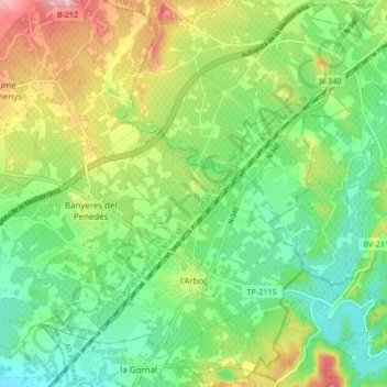
Name: l'Arboç topographic map, elevation, terrain.
Location: l'Arboç, Bas-Pénédais, Tarragone, Catalogne, 43720, Espagne (41.25039 1.57016 41.31349 1.64250)
Average elevation: 154 m
Minimum elevation: 93 m
Maximum elevation: 258 m
Other topographic maps
Click on a map to view its topography, its elevation and its terrain.
el Vendrell
Espagne > Catalogne > Bas-Pénédais
el Vendrell, Bas-Pénédais, Tarragone, Catalogne, 43700, Espagne
Average elevation: 67 m
Bonastre
Espagne > Catalogne > Bas-Pénédais
Bonastre, Bas-Pénédais, Tarragone, Catalogne, 43884, Espagne
Average elevation: 234 m
Banyeres del Penedès
Espagne > Catalogne > Bas-Pénédais
Banyeres del Penedès, Bas-Pénédais, Tarragone, Catalogne, 43711, Espagne
Average elevation: 144 m