Geolocate

Alcolea topographic map

Click on the map to display elevation.

About this map

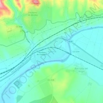
Name: Alcolea topographic map, elevation, terrain.

Location: Alcolea, Córdoba, Andalucía, 14610, España (37.91243 -4.68991 37.95243 -4.64991)

Average elevation: 137 m

Minimum elevation: 99 m

Maximum elevation: 261 m

Other topographic maps

Click on a map to view its topography, its elevation and its terrain.

Parque Cruz Conde

España > Andalucía > Córdoba

Average elevation: 108 m

Ciudad Jardín

España > Andalucía > Córdoba

Average elevation: 118 m

Las Jaras

España > Andalucía > Córdoba

Average elevation: 476 m

Gear up for your next adventure:

🧦Outdoor Socks - Durable socks designed for hiking and outdoor sports
🪜Heavy Duty Carabiners - Multi-use clips for securing gear to your backpack
🏃Hydration Running Vest - Carry water and maps close to your body for speed
🧤Thermal Hiking Gloves - Grip-enhanced gloves for cold-weather altitude trekking
💧Hydration Pack - Hands-free hydration system for long hikes

As an Amazon Associate, this site earns from qualifying purchases at no extra cost to you.