Geolocate

Lincoln topographic map

Click on the map to display elevation.

About this map

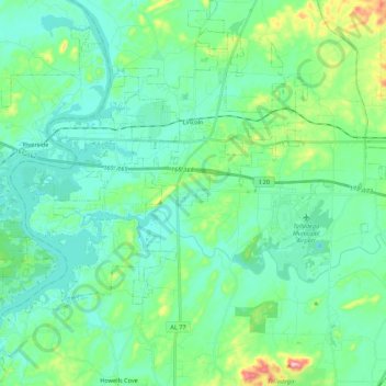
Name: Lincoln topographic map, elevation, terrain.

Location: Lincoln, Talladega County, Alabama, United States (33.48922 -86.23507 33.67009 -86.01950)

Average elevation: 169 m

Minimum elevation: 130 m

Maximum elevation: 320 m

Other topographic maps

Click on a map to view its topography, its elevation and its terrain.

Mignon

United States > Alabama > Talladega County

Average elevation: 172 m

Saint Ives

United States > Alabama > Talladega County

Average elevation: 157 m

Sand Mountain

United States > Alabama > Talladega County

Average elevation: 202 m

Fayetteville

United States > Alabama > Talladega County

Average elevation: 145 m

Echo Hills

United States > Alabama > Talladega County > Lincoln

Average elevation: 172 m

The Moon

United States > Alabama > Talladega County > Sylacauga

Average elevation: 199 m

Oxford

United States > Alabama > Talladega County > Oxford

Average elevation: 185 m

Colony

United States > Alabama > Talladega County > Lincoln

Average elevation: 151 m

Oxford

United States > Alabama > Talladega County

Average elevation: 197 m

Gear up for your next adventure:

🛁Quick-Dry Microfiber Towel - Space-saving towel that dries rapidly on the move
🛰️Satellite Messenger - Emergency communication for areas with no cell service
🦶Anti-Blister Balm - Prevents friction and hotspots during long ascents
🧭GPS Tracker - Track your location in remote areas safely
Camping Coffee Maker - Brew fresh coffee anywhere on the topographic map

As an Amazon Associate, this site earns from qualifying purchases at no extra cost to you.