Geolocate

Bath topographic map

Click on the map to display elevation.

About this map

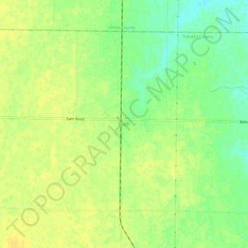
Name: Bath topographic map, elevation, terrain.

Location: Bath, Franklin County, Indiana, 47010, United States (39.48838 -84.88246 39.52838 -84.84246)

Average elevation: 312 m

Minimum elevation: 297 m

Maximum elevation: 320 m

Other topographic maps

Click on a map to view its topography, its elevation and its terrain.

Oldenburg

United States > Indiana > Franklin County

Average elevation: 288 m

Mount Carmel

United States > Indiana > Franklin County

Average elevation: 307 m

Gear up for your next adventure:

🥾Trail Running Shoes - Lightweight and durable shoes for trail running
🦌Outdoor Trail Camera - Monitor wildlife activity near your favorite spots
🧳Compression Sacks - Maximize space in your backpack by shrinking gear
🧢Outdoor Cap - Protective cap for sun and rain during hikes
🧥Insulated Jacket - Keep warm in cold outdoor conditions

As an Amazon Associate, this site earns from qualifying purchases at no extra cost to you.