Geolocate

Everton topographic map

Click on the map to display elevation.

About this map

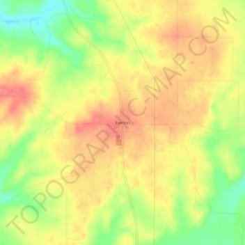
Name: Everton topographic map, elevation, terrain.

Location: Everton, Fayette County, Indiana, United States (39.54283 -85.10968 39.58283 -85.06968)

Average elevation: 304 m

Minimum elevation: 263 m

Maximum elevation: 331 m

Gear up for your next adventure:

🛶Waterproof Dry Bags - Keep electronics and clothes dry during river crossings
🔪Outdoor Multitool - Versatile tool for repairs and food prep in the wild
Camping Groundsheet - Protect your tent from moisture and dirt
🏃Hydration Running Vest - Carry water and maps close to your body for speed
🥾Lightweight Hiking Shoes - Comfortable shoes for day hikes

As an Amazon Associate, this site earns from qualifying purchases at no extra cost to you.