
Make a donation
Gear up for your next adventure:
As an Amazon Associate, this site earns from qualifying purchases at no extra cost to you.
Rio de Mouro topographic map
Click on the map to display elevation.
Make a donation
Gear up for your next adventure:
As an Amazon Associate, this site earns from qualifying purchases at no extra cost to you.
About this map
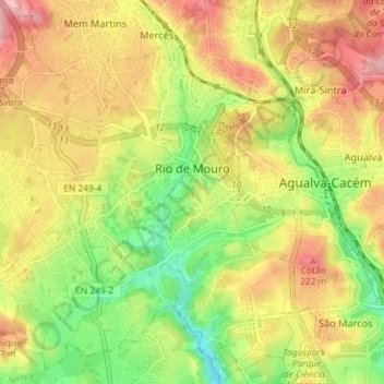
Name: Rio de Mouro topographic map, elevation, terrain.
Location: Rio de Mouro, Sintra, Lisbon, Portugal (38.74075 -9.35957 38.79704 -9.30589)
Average elevation: 157 m
Minimum elevation: 69 m
Maximum elevation: 244 m
Make a donation
Gear up for your next adventure:
As an Amazon Associate, this site earns from qualifying purchases at no extra cost to you.
Other topographic maps
Click on a map to view its topography, its elevation and its terrain.
Make a donation
Gear up for your next adventure:
As an Amazon Associate, this site earns from qualifying purchases at no extra cost to you.
Negrais
Portugal > Lisbon > Sintra > Almargem do Bispo, Pêro Pinheiro e Montelavar
Average elevation: 214 m
Alfouvar de Cima
Portugal > Lisbon > Sintra > Almargem do Bispo, Pêro Pinheiro e Montelavar
Average elevation: 193 m