Geolocate

Castala topographic map

Click on the map to display elevation.

About this map

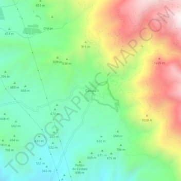
Name: Castala topographic map, elevation, terrain.

Location: Castala, Berja, Almería, Andalucía, España (36.86513 -2.94742 36.90513 -2.90742)

Average elevation: 808 m

Minimum elevation: 452 m

Maximum elevation: 1,416 m

Other topographic maps

Click on a map to view its topography, its elevation and its terrain.

Río Adra

España > Andalucía > Berja

Average elevation: 270 m

Gear up for your next adventure:

🧊Portable Cooler - Keep food and drinks cold during outdoor adventures
🔪Outdoor Multitool - Versatile tool for repairs and food prep in the wild
Backpacking Tent - Lightweight tent for long-distance hiking trips
🧤Thermal Hiking Gloves - Grip-enhanced gloves for cold-weather altitude trekking
🧦Hiking Liner Socks - Thin base layer to prevent friction and blisters

As an Amazon Associate, this site earns from qualifying purchases at no extra cost to you.