Geolocate

Masi topographic map

Click on the map to display elevation.

About this map

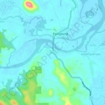
Name: Masi topographic map, elevation, terrain.

Location: Masi, Pamplona, Cagayan, Cagayan Valley, Philippines (18.43694 121.31743 18.47694 121.35743)

Average elevation: 14 m

Minimum elevation: -4 m

Maximum elevation: 105 m

Gear up for your next adventure:

🥫Freeze-Dried Meals - Lightweight, high-calorie nutrition for multi-day treks
🥾Waterproof Hiking Shoes - Durable shoes for wet and rugged trails
Tent Footprint - Protect tent floor and increase durability
Camping Groundsheet - Protect your tent from moisture and dirt
🧤Insulated Winter Gloves - Heavy-duty protection for sub-zero Canadian adventures

As an Amazon Associate, this site earns from qualifying purchases at no extra cost to you.