
Thank you for supporting this site ❤️
Make a donation
Make a donation
Gear up for your next adventure:
As an Amazon Associate, this site earns from qualifying purchases at no extra cost to you.
Nkuringo topographic map
Click on the map to display elevation.
Thank you for supporting this site ❤️
Make a donation
Make a donation
Gear up for your next adventure:
As an Amazon Associate, this site earns from qualifying purchases at no extra cost to you.
About this map
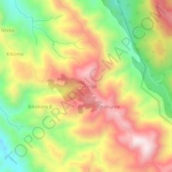
Name: Nkuringo topographic map, elevation, terrain.
Location: Nkuringo, Kisoro, Western Region, Uganda (-1.09848 29.60520 -1.05848 29.64520)
Average elevation: 1,859 m
Minimum elevation: 1,487 m
Maximum elevation: 2,215 m
Thank you for supporting this site ❤️
Make a donation
Make a donation
Gear up for your next adventure:
As an Amazon Associate, this site earns from qualifying purchases at no extra cost to you.