
Make a donation
Gear up for your next adventure:
As an Amazon Associate, this site earns from qualifying purchases at no extra cost to you.
Mahaffey topographic map
Click on the map to display elevation.
Make a donation
Gear up for your next adventure:
As an Amazon Associate, this site earns from qualifying purchases at no extra cost to you.
About this map
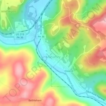
Name: Mahaffey topographic map, elevation, terrain.
Average elevation: 450 m
Minimum elevation: 381 m
Maximum elevation: 536 m
Make a donation
Gear up for your next adventure:
As an Amazon Associate, this site earns from qualifying purchases at no extra cost to you.
Other topographic maps
Click on a map to view its topography, its elevation and its terrain.
Make a donation
Gear up for your next adventure:
As an Amazon Associate, this site earns from qualifying purchases at no extra cost to you.
Make a donation
Gear up for your next adventure:
As an Amazon Associate, this site earns from qualifying purchases at no extra cost to you.
West Decatur
United States > Pennsylvania > Clearfield County > Boggs Township
Average elevation: 509 m
Beccaria
United States > Pennsylvania > Clearfield County > Beccaria Township
Average elevation: 467 m
Karthaus
United States > Pennsylvania > Clearfield County > Karthaus Township
Average elevation: 357 m
Make a donation
Gear up for your next adventure:
As an Amazon Associate, this site earns from qualifying purchases at no extra cost to you.
Lecontes Mills
United States > Pennsylvania > Clearfield County > Girard Township
Average elevation: 424 m
Luthersburg
United States > Pennsylvania > Clearfield County > Brady Township
Average elevation: 538 m
Make a donation
Gear up for your next adventure:
As an Amazon Associate, this site earns from qualifying purchases at no extra cost to you.
New Millport
United States > Pennsylvania > Clearfield County > Knox Township
Average elevation: 472 m
Pottersdale
United States > Pennsylvania > Clearfield County > Karthaus Township
Average elevation: 394 m
Make a donation
Gear up for your next adventure:
As an Amazon Associate, this site earns from qualifying purchases at no extra cost to you.
Woodland
United States > Pennsylvania > Clearfield County > Bradford Township
Average elevation: 505 m
Utahville
United States > Pennsylvania > Clearfield County > Beccaria Township > Utahville
Average elevation: 503 m
Anderson
United States > Pennsylvania > Clearfield County > Union Township > Anderson
Average elevation: 552 m
Make a donation
Gear up for your next adventure:
As an Amazon Associate, this site earns from qualifying purchases at no extra cost to you.
Parsonsville
United States > Pennsylvania > Clearfield County > Decatur Township
Average elevation: 496 m