Geolocate

Crest topographic map

Click on the map to display elevation.

About this map

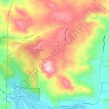
Name: Crest topographic map, elevation, terrain.

Location: Crest, San Diego County, California, United States (32.77906 -116.89370 32.82496 -116.84090)

Average elevation: 351 m

Minimum elevation: 131 m

Maximum elevation: 575 m

Gear up for your next adventure:

🔥Emergency Fire Starter - Reliable ignition source for all weather conditions
🥾Lightweight Hiking Boots - Boots for comfort and mobility on long hikes
🐕Hiking Dog Pack - Let your canine companion carry their own water and food
🌬️Windproof Camp Stove - Efficient cooking even on exposed mountain peaks
🦯Trekking Poles - Reduced impact on joints for steep topographic climbs

As an Amazon Associate, this site earns from qualifying purchases at no extra cost to you.