Geolocate

Tesistán topographic map

Click on the map to display elevation.

About this map

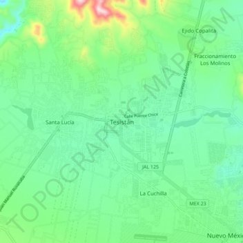
Name: Tesistán topographic map, elevation, terrain.

Location: Tesistán, Zapopan, Jalisco, 45200, Mexico (20.75892 -103.51676 20.83892 -103.43676)

Average elevation: 1,616 m

Minimum elevation: 1,522 m

Maximum elevation: 1,894 m

Gear up for your next adventure:

💧Hydration Pack - Hands-free hydration system for long hikes
🥾Approach Shoes - Shoes designed for climbing approaches and rugged trails
🧣Evaporative Cooling Towel - Beat the heat during intense summer climbs
🧴Sunscreen SPF - Broad-spectrum sunscreen for outdoor activities
🧶550 Survival Paracord - Versatile utility cord for emergency repairs and rigging

As an Amazon Associate, this site earns from qualifying purchases at no extra cost to you.