
Thank you for supporting this site ❤️
Make a donation
Make a donation
Gear up for your next adventure:
As an Amazon Associate, this site earns from qualifying purchases at no extra cost to you.
Tilottama topographic map
Click on the map to display elevation.
Thank you for supporting this site ❤️
Make a donation
Make a donation
Gear up for your next adventure:
As an Amazon Associate, this site earns from qualifying purchases at no extra cost to you.
About this map
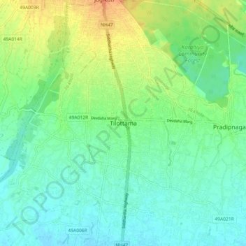
Name: Tilottama topographic map, elevation, terrain.
Location: Tilottama, Rupandehi, Lumbini Province, 32903, Nepal (27.58773 83.43206 27.66773 83.51206)
Average elevation: 130 m
Minimum elevation: 117 m
Maximum elevation: 157 m
Thank you for supporting this site ❤️
Make a donation
Make a donation
Gear up for your next adventure:
As an Amazon Associate, this site earns from qualifying purchases at no extra cost to you.