
Make a donation
Gear up for your next adventure:
As an Amazon Associate, this site earns from qualifying purchases at no extra cost to you.
Grande Terre topographic map
Click on the map to display elevation.
Make a donation
Gear up for your next adventure:
As an Amazon Associate, this site earns from qualifying purchases at no extra cost to you.
Grande Terre
The island is located roughly 1,300 kilometres (810 mi; 700 nmi) east of Australia. Grande Terre is oriented northwest-to-southeast; its area is 16,372 square kilometres (6,321 square miles). It is nearly 400 kilometres (250 miles) in length and 50–70 km (30–40 mi) wide in most places. A mountain range runs the length of the island, with five peaks over 1,500 metres (4,900 feet). The highest point is Mont Panié at 1,628 m (5,341 ft) elevation. Grande Terre is one of the largest islands in the Pacific Ocean.
Make a donation
Gear up for your next adventure:
As an Amazon Associate, this site earns from qualifying purchases at no extra cost to you.
About this map
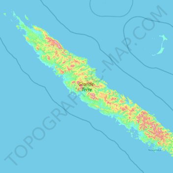
Name: Grande Terre topographic map, elevation, terrain.
Location: Grande Terre, New Caledonia, France (-22.39554 163.99535 -20.07560 167.03336)
Average elevation: 44 m
Minimum elevation: -1 m
Maximum elevation: 1,573 m
Make a donation
Gear up for your next adventure:
As an Amazon Associate, this site earns from qualifying purchases at no extra cost to you.
Other topographic maps
Click on a map to view its topography, its elevation and its terrain.
Roche de Solutré
France > Bourgogne-Franche-Comté > Saône-et-Loire > Solutré-Pouilly
Average elevation: 371 m
Make a donation
Gear up for your next adventure:
As an Amazon Associate, this site earns from qualifying purchases at no extra cost to you.
Le Moulin de Dore
France > Nouvelle-Aquitaine > Charente-Maritime > Barzan-Plage > Chez Pilou
Average elevation: 9 m
Make a donation
Gear up for your next adventure:
As an Amazon Associate, this site earns from qualifying purchases at no extra cost to you.
Le Colombier
France > Nouvelle-Aquitaine > Corrèze > Lamazière-Basse > Le Colombier
Average elevation: 516 m
Luchon-Superbagnères
France > Occitania > Saint-Aventin > Luchon-Superbagnères
Average elevation: 1,331 m
Make a donation
Gear up for your next adventure:
As an Amazon Associate, this site earns from qualifying purchases at no extra cost to you.
Île de Vassivière
France > Nouvelle-Aquitaine > Haute-Vienne > Beaumont-du-Lac
Average elevation: 664 m