
Weerselo topographic map
Interactive map
Click on the map to display elevation.
About this map
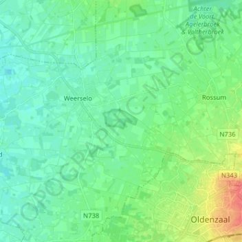
Name: Weerselo topographic map, elevation, terrain.
Location: Weerselo, Dinkelland, Overijssel, Nederland (52.32118 6.79760 52.36597 6.92575)
Average elevation: 24 m
Minimum elevation: 11 m
Maximum elevation: 64 m
Other topographic maps
Click on a map to view its topography, its elevation and its terrain.
Dinkelland
Nederland > Overijssel > Dinkelland
Dinkelland, Overijssel, Nederland
Average elevation: 29 m
Deurningen
Nederland > Overijssel > Dinkelland
Deurningen, Dinkelland, Overijssel, Nederland
Average elevation: 22 m