Geolocate

Tambo topographic map

Click on the map to display elevation.

About this map

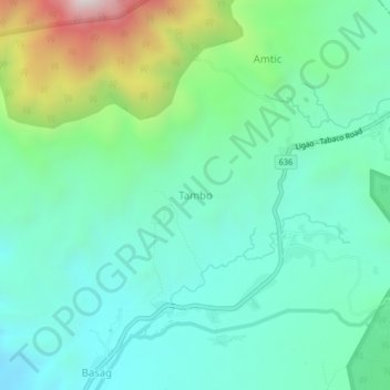
Name: Tambo topographic map, elevation, terrain.

Location: Tambo, Albay, Bicol Region, Philippines (13.26669 123.58822 13.30669 123.62822)

Average elevation: 336 m

Minimum elevation: 87 m

Maximum elevation: 1,087 m

Other topographic maps

Click on a map to view its topography, its elevation and its terrain.

Peñaranda Park

Philippines > Albay > Legazpi > Baño

Average elevation: 37 m

Malilipot

Philippines > Albay

Average elevation: 262 m

Rapu-Rapu

Philippines > Albay

Average elevation: 18 m

Gear up for your next adventure:

🎒Hiking Backpack - Lightweight and ergonomic backpacks for day hikes or multi-day treks
🕶️Polarized Sunglasses - Reduces glare from snow and water at high elevations
🛌Insulated Sleeping Pad - Critical thermal barrier between you and the cold ground
🧴Waterproofing Spray - Restore the DWR coating on jackets and tents
🧴First Aid Kit - Essential first aid supplies for outdoor emergencies

As an Amazon Associate, this site earns from qualifying purchases at no extra cost to you.