
Make a donation
Gear up for your next adventure:
As an Amazon Associate, this site earns from qualifying purchases at no extra cost to you.
Sinsin topographic map
Click on the map to display elevation.
Make a donation
Gear up for your next adventure:
As an Amazon Associate, this site earns from qualifying purchases at no extra cost to you.
About this map
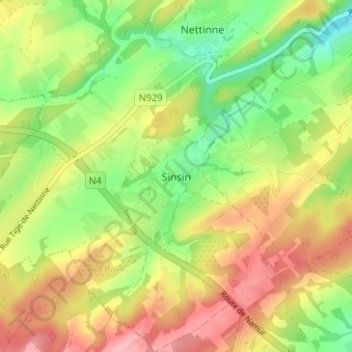
Name: Sinsin topographic map, elevation, terrain.
Location: Sinsin, Somme-Leuze, Dinant, Namur, Wallonie, 5377, Belgique (50.25363 5.23351 50.29363 5.27351)
Average elevation: 254 m
Minimum elevation: 194 m
Maximum elevation: 319 m
Make a donation
Gear up for your next adventure:
As an Amazon Associate, this site earns from qualifying purchases at no extra cost to you.
Other topographic maps
Click on a map to view its topography, its elevation and its terrain.
Make a donation
Gear up for your next adventure:
As an Amazon Associate, this site earns from qualifying purchases at no extra cost to you.
Onhaye
Le village d'Onhaye est un bourg étendu et étiré le long d'un tige (altitude jusqu'à 260 m) et sur le versant peu incliné s'orientant vers le sud. Le village se rassemble autour de l'église et de quelques fermes importantes. Il a été édifié en pierre calcaire mais aussi en brique dès la fin du XVIII…
Average elevation: 200 m