
Fish Lake topographic map
Interactive map
Click on the map to display elevation.
About this map
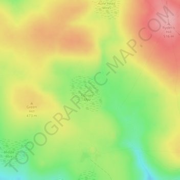
Name: Fish Lake topographic map, elevation, terrain.
Average elevation: 456 m
Minimum elevation: 391 m
Maximum elevation: 513 m
Other topographic maps
Click on a map to view its topography, its elevation and its terrain.
West Devon
United Kingdom > England > West Devon
West Devon, Devon, South West England, England, United Kingdom
Average elevation: 200 m
Shoalgate Cross
United Kingdom > England > West Devon
Shoalgate Cross, West Devon, Devon, South West England, England, EX20 2RZ, United Kingdom
Average elevation: 190 m
North Tawton
United Kingdom > England > West Devon > North Tawton
North Tawton, West Devon, Devon, South West England, England, EX20 2HD, United Kingdom
Average elevation: 151 m