Geolocate

Havila topographic map

Click on the map to display elevation.

About this map

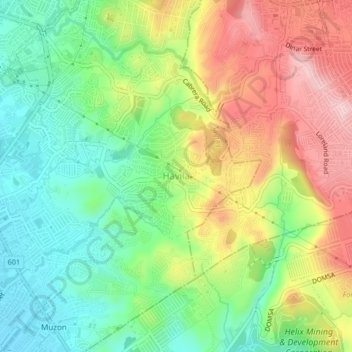
Name: Havila topographic map, elevation, terrain.

Location: Havila, Taytay, Rizal, Calabarzon, 1880, Philippines (14.54083 121.13887 14.58083 121.17887)

Average elevation: 106 m

Minimum elevation: 3 m

Maximum elevation: 249 m

Gear up for your next adventure:

🛶Kayak Dry Bag - Waterproof storage for kayaking adventures
👟Leg Gaiters - Keep debris, mud, and snow out of your boots
🥾Trekking Boots - Durable boots for long-distance trekking
🧭GPS Handheld Device - Reliable GPS navigation for outdoor adventures
🧥Waterproof Pants - Keep dry during rainy hiking conditions

As an Amazon Associate, this site earns from qualifying purchases at no extra cost to you.