
Make a donation
Gear up for your next adventure:
As an Amazon Associate, this site earns from qualifying purchases at no extra cost to you.
Paramos topographic map
Click on the map to display elevation.
Make a donation
Gear up for your next adventure:
As an Amazon Associate, this site earns from qualifying purchases at no extra cost to you.
Paramos
Posição: 40º 58′ 24″ N , 008º 38′ 43″ W ( ARP – eixo da pista, 100m da soleira da pista 17 ) Declinação Magnética: 04º 01′ (2006) Distância/Direcção à Localidade: 3 km / 1.6 nm S Altitude Máxima: 3m / 10′
Make a donation
Gear up for your next adventure:
As an Amazon Associate, this site earns from qualifying purchases at no extra cost to you.
About this map
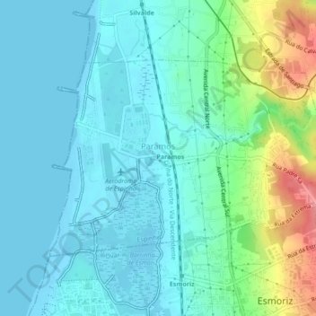
Name: Paramos topographic map, elevation, terrain.
Location: Paramos, Espinho, Aveiro, Portugal (40.96478 -8.65312 40.98473 -8.61070)
Average elevation: 20 m
Minimum elevation: -2 m
Maximum elevation: 90 m
Make a donation
Gear up for your next adventure:
As an Amazon Associate, this site earns from qualifying purchases at no extra cost to you.
Other topographic maps
Click on a map to view its topography, its elevation and its terrain.
Make a donation
Gear up for your next adventure:
As an Amazon Associate, this site earns from qualifying purchases at no extra cost to you.