
Make a donation
Gear up for your next adventure:
As an Amazon Associate, this site earns from qualifying purchases at no extra cost to you.
Saussa topographic map
Click on the map to display elevation.
Make a donation
Gear up for your next adventure:
As an Amazon Associate, this site earns from qualifying purchases at no extra cost to you.
About this map
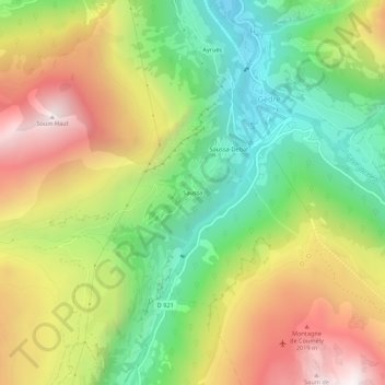
Name: Saussa topographic map, elevation, terrain.
Average elevation: 1,548 m
Minimum elevation: 954 m
Maximum elevation: 2,294 m
Make a donation
Gear up for your next adventure:
As an Amazon Associate, this site earns from qualifying purchases at no extra cost to you.
Other topographic maps
Click on a map to view its topography, its elevation and its terrain.
Glacier de la Munia
France > Occitanie > Hautes-Pyrénées > Gavarnie-Gèdre > Gèdre
Average elevation: 2,547 m
Glacier d'Astazou
France > Occitanie > Hautes-Pyrénées > Gavarnie-Gèdre > Gèdre
Average elevation: 2,482 m
Lac des Gloriettes
France > Occitanie > Hautes-Pyrénées > Gavarnie-Gèdre > Gèdre
Average elevation: 1,917 m
Make a donation
Gear up for your next adventure:
As an Amazon Associate, this site earns from qualifying purchases at no extra cost to you.