
Make a donation
Gear up for your next adventure:
As an Amazon Associate, this site earns from qualifying purchases at no extra cost to you.
Sauldorf topographic map
Click on the map to display elevation.
Make a donation
Gear up for your next adventure:
As an Amazon Associate, this site earns from qualifying purchases at no extra cost to you.
About this map
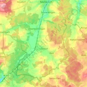
Name: Sauldorf topographic map, elevation, terrain.
Average elevation: 643 m
Minimum elevation: 585 m
Maximum elevation: 711 m
Make a donation
Gear up for your next adventure:
As an Amazon Associate, this site earns from qualifying purchases at no extra cost to you.
Other topographic maps
Click on a map to view its topography, its elevation and its terrain.
Ettisweiler
Deutschland > Baden-Württemberg > Landkreis Sigmaringen > Bittelschieß
Average elevation: 625 m
Feldhausen
Deutschland > Baden-Württemberg > Landkreis Sigmaringen > Gammertingen
Average elevation: 773 m
Herdwangen
Deutschland > Baden-Württemberg > Landkreis Sigmaringen
Herdwangen liegt zwölf Kilometer nördlich des Bodensees, auf einem Höhenzug im Oberen Linzgau, an der Landstraße zwischen den Städten Pfullendorf im Norden und Überlingen im Süden.
Average elevation: 658 m
Make a donation
Gear up for your next adventure:
As an Amazon Associate, this site earns from qualifying purchases at no extra cost to you.
Oberschmeien
Deutschland > Baden-Württemberg > Landkreis Sigmaringen > Sigmaringen
Average elevation: 704 m
Levertsweiler
Deutschland > Baden-Württemberg > Landkreis Sigmaringen > Ostrach
Average elevation: 623 m