
Make a donation
Gear up for your next adventure:
As an Amazon Associate, this site earns from qualifying purchases at no extra cost to you.
Herbisried topographic map
Click on the map to display elevation.
Make a donation
Gear up for your next adventure:
As an Amazon Associate, this site earns from qualifying purchases at no extra cost to you.
Herbisried
Herbisried liegt in Oberschwaben in der Donau-Iller-Region, etwa drei Kilometer südlich von Bad Grönenbach, auf einer Höhe von 769 m ü. NN. An Herbisried grenzen im Uhrzeigersinn, im Norden beginnend, der Markt Bad Grönenbach, die Weiler Kornhofen, Hueb, Gmeinschwenden, Sommersberg und Greit. Mit Ausnahme des im Landkreis Oberallgäu liegenden Weilers Sommersberg befinden sich alle anderen Orte im Landkreis Unterallgäu.
Make a donation
Gear up for your next adventure:
As an Amazon Associate, this site earns from qualifying purchases at no extra cost to you.
About this map
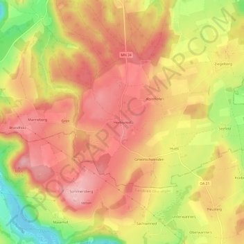
Name: Herbisried topographic map, elevation, terrain.
Average elevation: 731 m
Minimum elevation: 625 m
Maximum elevation: 793 m
Make a donation
Gear up for your next adventure:
As an Amazon Associate, this site earns from qualifying purchases at no extra cost to you.