Geolocate

Joho topographic map

Click on the map to display elevation.

About this map

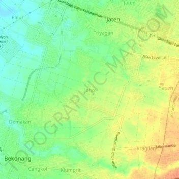
Name: Joho topographic map, elevation, terrain.

Location: Joho, Sukoharjo, Central Java, Java, 57554, Indonesia (-7.61337 110.87021 -7.57337 110.91021)

Average elevation: 111 m

Minimum elevation: 91 m

Maximum elevation: 130 m

Other topographic maps

Click on a map to view its topography, its elevation and its terrain.

Bulu

Indonesia > Central Java > Sukoharjo

Average elevation: 126 m

Puron

Indonesia > Central Java > Sukoharjo

Average elevation: 128 m

Lapangan Makamhaji

Indonesia > Central Java > Sukoharjo > Gentan > Kuyudan

Average elevation: 104 m

Waduk Mulur

Indonesia > Central Java > Sukoharjo > Bendosari

Average elevation: 114 m

Karangasem

Indonesia > Central Java > Sukoharjo > Karangasem

Average elevation: 115 m

Gear up for your next adventure:

📷Outdoor Action Camera - Capture high-elevation views and rugged adventures
🪑Insulated Seat Pad - Protect your seat from cold rocks and wet logs
🥾Lightweight Hiking Shoes - Comfortable shoes for day hikes
🧼Biodegradable Camp Soap - Environmentally friendly cleaning for gear and body
🥾Waterproof Trail Shoes - Shoes designed to handle wet terrain

As an Amazon Associate, this site earns from qualifying purchases at no extra cost to you.