Geolocate

Cihaurbeuti topographic map

Click on the map to display elevation.

About this map

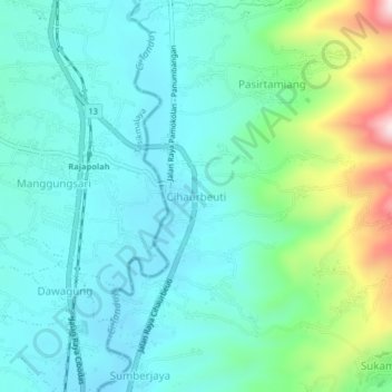
Name: Cihaurbeuti topographic map, elevation, terrain.

Location: Cihaurbeuti, Ciamis, West Java, Java, 46262, Indonesia (-7.24391 108.18224 -7.20391 108.22224)

Average elevation: 516 m

Minimum elevation: 420 m

Maximum elevation: 852 m

Other topographic maps

Click on a map to view its topography, its elevation and its terrain.

Ciamis

Indonesia > West Java > Ciamis

Ciamis Regency consists of 328 villages, with the topography predominantly characterized by 153 villages in the plains, 162 villages on the slopes, and 13 villages in the Watershed (DAS) area.

Average elevation: 217 m

Linggasari

Indonesia > West Java > Ciamis > Ciamis

Average elevation: 218 m

Cikoneng

Indonesia > West Java > Ciamis

Average elevation: 492 m

Bojongmengger

Indonesia > West Java > Ciamis

Average elevation: 118 m

Gear up for your next adventure:

🔥Emergency Fire Starter - Reliable ignition source for all weather conditions
🧤Rechargeable Heated Gloves - Extreme warmth for Canadian winter expeditions
🔦LED Headtorch - Bright and durable light for night activities
🪑Insulated Seat Pad - Protect your seat from cold rocks and wet logs
🎒Hiking Backpack - Lightweight and ergonomic backpacks for day hikes or multi-day treks

As an Amazon Associate, this site earns from qualifying purchases at no extra cost to you.