
Make a donation
Gear up for your next adventure:
As an Amazon Associate, this site earns from qualifying purchases at no extra cost to you.
Vella Lavella topographic map
Click on the map to display elevation.
Make a donation
Gear up for your next adventure:
As an Amazon Associate, this site earns from qualifying purchases at no extra cost to you.
Vella Lavella
The island of Vella Lavella is located in the southwestern Pacific Ocean. To the north is the island of Choiseul, to the northwest is the island of Shortland, and to the southeast is the island of New Georgia. Vella Lavella is a volcanic island, surrounded in some places by a coral reef. The island contains volcanic cones and one thermal spring. The highest elevation is Mount Tambisala at 790 metres (2,590 ft). The volcano Nonda, the youngest volcano of the island, has an elevation of 750 meters and is considered active, although it has never erupted in modern times. The smaller rivers running from the mountains to the coast allow irrigated horticulture to the inhabitants who live almost exclusively on the coast. Vella Lavella is mainly vegetated with lowland rainforest. The climate is wet and tropical, and the island is prone to earthquakes and cyclones.
Make a donation
Gear up for your next adventure:
As an Amazon Associate, this site earns from qualifying purchases at no extra cost to you.
About this map
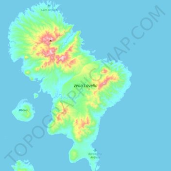
Name: Vella Lavella topographic map, elevation, terrain.
Location: Vella Lavella, Western, Solomon Islands (-7.96048 156.50017 -7.56299 156.79176)
Average elevation: 58 m
Minimum elevation: -1 m
Maximum elevation: 780 m
Make a donation
Gear up for your next adventure:
As an Amazon Associate, this site earns from qualifying purchases at no extra cost to you.
Other topographic maps
Click on a map to view its topography, its elevation and its terrain.
Make a donation
Gear up for your next adventure:
As an Amazon Associate, this site earns from qualifying purchases at no extra cost to you.