
Make a donation
Gear up for your next adventure:
As an Amazon Associate, this site earns from qualifying purchases at no extra cost to you.
Sabuscles topographic map
Click on the map to display elevation.
Make a donation
Gear up for your next adventure:
As an Amazon Associate, this site earns from qualifying purchases at no extra cost to you.
About this map
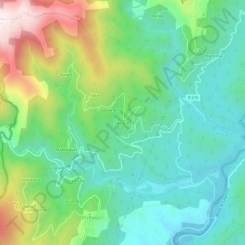
Name: Sabuscles topographic map, elevation, terrain.
Average elevation: 425 m
Minimum elevation: 213 m
Maximum elevation: 907 m
Make a donation
Gear up for your next adventure:
As an Amazon Associate, this site earns from qualifying purchases at no extra cost to you.
Other topographic maps
Click on a map to view its topography, its elevation and its terrain.
La Ganière
France > Auvergne-Rhône-Alpes > Ardèche > Malbosc
De 27,3 km de longueur, la Ganière est une rivière aurifère aux environs de Bessèges qui prend sa source sur la commune de Malons-et-Elze, entre le Serre de Taravel (969 m) et le mont Redon (884 m), à 857 m d'altitude. Il s'appelle d'abord en partie haute le Valat de la Bachasside, puis le ruisseau du…
Average elevation: 371 m