
Besse topographic map
Click on the map to display elevation.
About this map
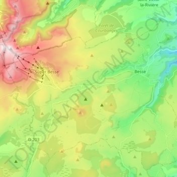
Name: Besse topographic map, elevation, terrain.
Average elevation: 1,225 m
Minimum elevation: 819 m
Maximum elevation: 1,848 m
Other topographic maps
Click on a map to view its topography, its elevation and its terrain.
Cascades de Chiloza
France > Auvergne-Rhône-Alpes > Puy-de-Dôme > Besse-et-Saint-Anastaise
Average elevation: 967 m
Vassivière
France > Auvergne-Rhône-Alpes > Puy-de-Dôme > Besse-et-Saint-Anastaise
Average elevation: 1,283 m
Serre-Bas
France > Auvergne-Rhône-Alpes > Puy-de-Dôme > Besse-et-Saint-Anastaise
Average elevation: 1,049 m
Combes
France > Auvergne-Rhône-Alpes > Puy-de-Dôme > Besse-et-Saint-Anastaise
Average elevation: 1,053 m
Le Rif
France > Auvergne-Rhône-Alpes > Puy-de-Dôme > Besse-et-Saint-Anastaise
Average elevation: 1,070 m
Les Courtes
France > Auvergne-Rhône-Alpes > Puy-de-Dôme > Besse-et-Saint-Anastaise
Average elevation: 1,081 m
La Ville-Tour
France > Auvergne-Rhône-Alpes > Puy-de-Dôme > Besse-et-Saint-Anastaise
Average elevation: 1,108 m
Le Stade
France > Auvergne-Rhône-Alpes > Puy-de-Dôme > Besse-et-Saint-Anastaise
Average elevation: 1,102 m
Bois de Gravière
France > Auvergne-Rhône-Alpes > Puy-de-Dôme > Besse-et-Saint-Anastaise
Average elevation: 1,053 m
La Gazelle
France > Auvergne-Rhône-Alpes > Puy-de-Dôme > Besse-et-Saint-Anastaise
Average elevation: 1,090 m
Serre-Haut
France > Auvergne-Rhône-Alpes > Puy-de-Dôme > Besse-et-Saint-Anastaise
Average elevation: 1,047 m
Lignerolles
France > Auvergne-Rhône-Alpes > Puy-de-Dôme > Besse-et-Saint-Anastaise
Average elevation: 1,032 m
Puy de Chambourguet
France > Auvergne-Rhône-Alpes > Puy-de-Dôme > Besse-et-Saint-Anastaise
Average elevation: 1,352 m
Puy de Pertuyzat
France > Auvergne-Rhône-Alpes > Puy-de-Dôme > Besse-et-Saint-Anastaise
Average elevation: 1,192 m
Le Pont du Roy
France > Auvergne-Rhône-Alpes > Puy-de-Dôme > Besse-et-Saint-Anastaise
Average elevation: 1,071 m
Péalat
France > Auvergne-Rhône-Alpes > Puy-de-Dôme > Besse-et-Saint-Anastaise
Average elevation: 1,169 m
Anglard
France > Auvergne-Rhône-Alpes > Puy-de-Dôme > Besse-et-Saint-Anastaise
Average elevation: 1,154 m
Olpilière
France > Auvergne-Rhône-Alpes > Puy-de-Dôme > Besse-et-Saint-Anastaise
Average elevation: 1,100 m
Erissoux
France > Auvergne-Rhône-Alpes > Puy-de-Dôme > Besse-et-Saint-Anastaise
Average elevation: 1,078 m
Les Combes
France > Auvergne-Rhône-Alpes > Puy-de-Dôme > Besse-et-Saint-Anastaise
Average elevation: 1,097 m
Montredon
France > Auvergne-Rhône-Alpes > Puy-de-Dôme > Besse-et-Saint-Anastaise
Average elevation: 967 m
Les Courtes
France > Auvergne-Rhône-Alpes > Puy-de-Dôme > Besse-et-Saint-Anastaise
Average elevation: 1,081 m