
Make a donation
Gear up for your next adventure:
As an Amazon Associate, this site earns from qualifying purchases at no extra cost to you.
Le Village topographic map
Click on the map to display elevation.
Make a donation
Gear up for your next adventure:
As an Amazon Associate, this site earns from qualifying purchases at no extra cost to you.
About this map
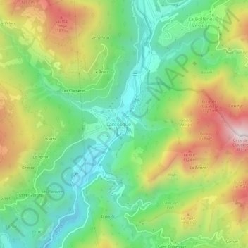
Name: Le Village topographic map, elevation, terrain.
Average elevation: 754 m
Minimum elevation: 382 m
Maximum elevation: 1,346 m
Make a donation
Gear up for your next adventure:
As an Amazon Associate, this site earns from qualifying purchases at no extra cost to you.
Other topographic maps
Click on a map to view its topography, its elevation and its terrain.
La Vésubie
France > Provence-Alpes-Côte d'Azur > Alpes-Maritimes > Lantosque > Le Suquet
La Vésubie conflue entre les communes de Levens et Bonson, à environ 140 m d'altitude.
Average elevation: 545 m
Le Serre de Troupel
France > Provence-Alpes-Côte d'Azur > Alpes-Maritimes > Lantosque > Pélasque
Average elevation: 767 m