Geolocate

Murshet topographic map

Click on the map to display elevation.

About this map

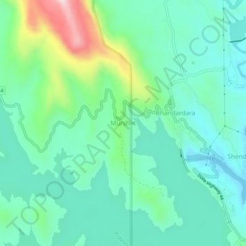
Name: Murshet topographic map, elevation, terrain.

Location: Murshet, Akola, Ahmednagar District, Maharashtra, India (19.53344 73.72682 19.57344 73.76682)

Average elevation: 775 m

Minimum elevation: 671 m

Maximum elevation: 1,098 m

Other topographic maps

Click on a map to view its topography, its elevation and its terrain.

Nizampur

India > Maharashtra > Akola

Average elevation: 280 m

Nawakheda

India > Maharashtra > Akola

Average elevation: 270 m

Pahadpur

India > Maharashtra > Akola

Average elevation: 299 m

Dongargaon

India > Maharashtra > Akola > Dongargaon

Average elevation: 294 m

Babhulgaon

India > Maharashtra > Akola > Babhulgaon

Average elevation: 294 m

Borgaon Manju

India > Maharashtra > Akola

Average elevation: 295 m

Hingna Barling

India > Maharashtra > Akola

Average elevation: 286 m

Kothari

India > Maharashtra > Akola

Average elevation: 299 m

Gear up for your next adventure:

🧼Biodegradable Camp Soap - Environmentally friendly cleaning for gear and body
Camping Coffee Maker - Brew fresh coffee anywhere on the topographic map
🥾Trail Hiking Socks - Comfortable socks to prevent blisters and fatigue
🧤Rechargeable Heated Gloves - Extreme warmth for Canadian winter expeditions
🚲Heavy Duty Bike Lock - Secure your bike at the trailhead or during stops

As an Amazon Associate, this site earns from qualifying purchases at no extra cost to you.