
Make a donation
Gear up for your next adventure:
As an Amazon Associate, this site earns from qualifying purchases at no extra cost to you.
Dolembreux topographic map
Click on the map to display elevation.
Make a donation
Gear up for your next adventure:
As an Amazon Associate, this site earns from qualifying purchases at no extra cost to you.
Dolembreux
Er lopen enkele beekjes door Dolembreux, dat in het zuiden begrensd wordt door het dal van de Haze. De hoogte aan de kerk bedraagt 238 meter.
Make a donation
Gear up for your next adventure:
As an Amazon Associate, this site earns from qualifying purchases at no extra cost to you.
About this map
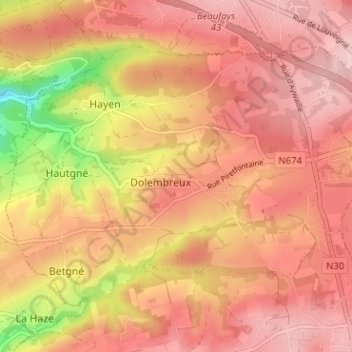
Name: Dolembreux topographic map, elevation, terrain.
Location: Dolembreux, Sprimont, Luik, Wallonië, 4140, België (50.52270 5.59724 50.55244 5.66066)
Average elevation: 237 m
Minimum elevation: 108 m
Maximum elevation: 296 m
Make a donation
Gear up for your next adventure:
As an Amazon Associate, this site earns from qualifying purchases at no extra cost to you.
Other topographic maps
Click on a map to view its topography, its elevation and its terrain.
Make a donation
Gear up for your next adventure:
As an Amazon Associate, this site earns from qualifying purchases at no extra cost to you.