Geolocate

Stanstead topographic map

Click on the map to display elevation.

About this map

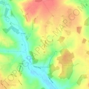
Name: Stanstead topographic map, elevation, terrain.

Location: Stanstead, Babergh, Suffolk, England, United Kingdom (52.09836 0.67580 52.13033 0.70843)

Average elevation: 67 m

Minimum elevation: 34 m

Maximum elevation: 96 m

Other topographic maps

Click on a map to view its topography, its elevation and its terrain.

Sudbury

United Kingdom > England > Suffolk > Babergh > Sudbury

Average elevation: 54 m

Little Wenham

United Kingdom > England > Suffolk > Babergh

Average elevation: 46 m

Gear up for your next adventure:

🧼Biodegradable Camp Soap - Environmentally friendly cleaning for gear and body
🧢Sun Hat - Wide-brim hat for sun protection
🔪Outdoor Multitool - Versatile tool for repairs and food prep in the wild
🥾Hiking Gaiters - Protect legs and shoes from mud, snow, and debris
🥾Durable Hiking Shoes - Long-lasting shoes for frequent hiking

As an Amazon Associate, this site earns from qualifying purchases at no extra cost to you.