
Three Oaks topographic map
Click on the map to display elevation.
About this map
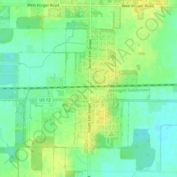
Name: Three Oaks topographic map, elevation, terrain.
Location: Three Oaks, Berrien County, Michigan, United States (41.79144 -86.62404 41.80966 -86.60243)
Average elevation: 203 m
Minimum elevation: 193 m
Maximum elevation: 213 m
Other topographic maps
Click on a map to view its topography, its elevation and its terrain.
Grand Mere State Park
United States > Michigan > Berrien County > Lincoln Charter Township
Average elevation: 185 m
Grand Mere State Park
United States > Michigan > Berrien County > Lincoln Charter Township
Average elevation: 185 m
Grand Mere State Park
United States > Michigan > Berrien County > Stevensville
Average elevation: 185 m
Grand Mere State Park
United States > Michigan > Berrien County > Stevensville
Average elevation: 185 m