Geolocate

Totora topographic map

Click on the map to display elevation.

👉 Easily get elevation data in JSON, GeoTIFF and KML formats using Elevation API
Thank you for supporting this site ❤️
Make a donation

About this map

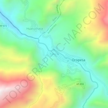
Name: Totora topographic map, elevation, terrain.

Location: Totora, Oropesa, Antabamba, Apurímac, Perú (-14.28043 -72.58368 -14.24043 -72.54368)

Average elevation: 3,653 m

Minimum elevation: 3,201 m

Maximum elevation: 4,437 m

Gear up for your next adventure:

🥾Hiking Shoes - Durable and comfortable shoes for trail hiking
Camping Groundsheet - Protect your tent from moisture and dirt
🕶️Polarized Sunglasses - Reduces glare from snow and water at high elevations
🧥Packable Rain Jacket - Breathable waterproof layer for unpredictable weather
💡LED Camping Lantern - Illuminate your campsite with long-lasting lanterns

As an Amazon Associate, this site earns from qualifying purchases at no extra cost to you.