
Make a donation
Gear up for your next adventure:
As an Amazon Associate, this site earns from qualifying purchases at no extra cost to you.
Tizi Ameur topographic map
Click on the map to display elevation.
Make a donation
Gear up for your next adventure:
As an Amazon Associate, this site earns from qualifying purchases at no extra cost to you.
About this map
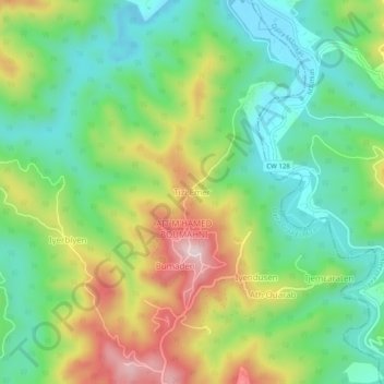
Name: Tizi Ameur topographic map, elevation, terrain.
Average elevation: 264 m
Minimum elevation: 128 m
Maximum elevation: 497 m
Make a donation
Gear up for your next adventure:
As an Amazon Associate, this site earns from qualifying purchases at no extra cost to you.
Other topographic maps
Click on a map to view its topography, its elevation and its terrain.
Make a donation
Gear up for your next adventure:
As an Amazon Associate, this site earns from qualifying purchases at no extra cost to you.
Frikat
Algérie > Tizi Ouzou > Daïra Draâ El Mizan
La commune dont la mairie se situe à 357 mètres d'altitude n'accueille aucune réserve naturelle sur son territoire.
Average elevation: 617 m