Geolocate

Logan topographic map

Click on the map to display elevation.

About this map

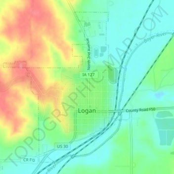
Name: Logan topographic map, elevation, terrain.

Location: Logan, Harrison County, Iowa, United States (41.63515 -95.80679 41.65849 -95.78119)

Average elevation: 337 m

Minimum elevation: 305 m

Maximum elevation: 390 m

Gear up for your next adventure:

🧭Orienteering Kit - Tools for map reading and navigation in the wild
🔦UV Flashlight - Detect minerals or specific insects in the dark
🥾Trail Running Shoes - Lightweight and durable shoes for trail running
🥾Waterproof Hiking Boots - Essential footwear for rugged terrain and wet Canadian trails
🧤Insulated Winter Gloves - Heavy-duty protection for sub-zero Canadian adventures

As an Amazon Associate, this site earns from qualifying purchases at no extra cost to you.