Geolocate

Chikhaldara topographic map

Click on the map to display elevation.

About this map

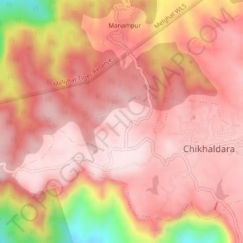
Name: Chikhaldara topographic map, elevation, terrain.

Location: Chikhaldara, Amravati, Maharashtra, India (21.39220 77.30159 21.41794 77.33549)

Average elevation: 1,015 m

Minimum elevation: 720 m

Maximum elevation: 1,115 m

Other topographic maps

Click on a map to view its topography, its elevation and its terrain.

Melghat Tiger Reserve

India > Maharashtra > Chikhaldara

Average elevation: 481 m

Chikhaldara

India > Maharashtra > Chikhaldara > Chikhaldara

Average elevation: 901 m

Dhargad

India > Maharashtra > Chikhaldara > Dhargad

Average elevation: 646 m

Gear up for your next adventure:

🔭Outdoor Binoculars - Lightweight binoculars for birdwatching and hiking
🌬️Windproof Camp Stove - Efficient cooking even on exposed mountain peaks
🧥Ultralight Puffy Jacket - Maximum warmth that packs down to the size of an orange
🧦Hiking Liner Socks - Thin base layer to prevent friction and blisters
🪑Insulated Seat Pad - Protect your seat from cold rocks and wet logs

As an Amazon Associate, this site earns from qualifying purchases at no extra cost to you.