Geolocate

St. Cloud topographic map

Click on the map to display elevation.

About this map

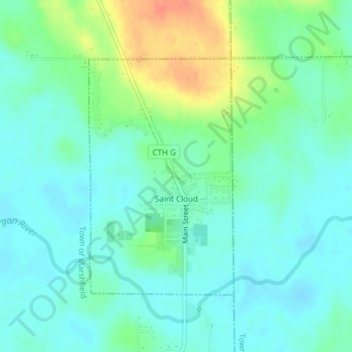
Name: St. Cloud topographic map, elevation, terrain.

Location: St. Cloud, Fond du Lac County, Wisconsin, United States (43.81537 -88.17637 43.83352 -88.16094)

Average elevation: 288 m

Minimum elevation: 274 m

Maximum elevation: 321 m

Other topographic maps

Click on a map to view its topography, its elevation and its terrain.

Waucousta

United States > Wisconsin > Fond du Lac County

Average elevation: 316 m

Eldorado

United States > Wisconsin > Fond du Lac County

Average elevation: 267 m

Gear up for your next adventure:

🧣Evaporative Cooling Towel - Beat the heat during intense summer climbs
🧴Outdoor Sunscreen - High SPF protection for high-altitude UV exposure
🧭GPS Outdoor Watch - Smart watch for navigation and fitness tracking in nature
🥾Trekking Boots - Durable boots for long-distance trekking
🐕Hiking Dog Pack - Let your canine companion carry their own water and food

As an Amazon Associate, this site earns from qualifying purchases at no extra cost to you.