
Make a donation
Gear up for your next adventure:
As an Amazon Associate, this site earns from qualifying purchases at no extra cost to you.
Bois-le-Roi topographic map
Click on the map to display elevation.
Make a donation
Gear up for your next adventure:
As an Amazon Associate, this site earns from qualifying purchases at no extra cost to you.
Bois-le-Roi
La commune est située à 139 mètres d'altitude, s'étend sur 542 hectares dont les forêts en recouvrent une superficie de 59 hectares et 70 ares, et occupe une place intermédiaire entre le plateau de Saint-André et la vallée de l'Eure.
Make a donation
Gear up for your next adventure:
As an Amazon Associate, this site earns from qualifying purchases at no extra cost to you.
About this map
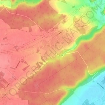
Name: Bois-le-Roi topographic map, elevation, terrain.
Average elevation: 120 m
Minimum elevation: 64 m
Maximum elevation: 142 m
Make a donation
Gear up for your next adventure:
As an Amazon Associate, this site earns from qualifying purchases at no extra cost to you.
Other topographic maps
Click on a map to view its topography, its elevation and its terrain.