
Make a donation
Gear up for your next adventure:
As an Amazon Associate, this site earns from qualifying purchases at no extra cost to you.
Monroe topographic map
Click on the map to display elevation.
Make a donation
Gear up for your next adventure:
As an Amazon Associate, this site earns from qualifying purchases at no extra cost to you.
Monroe
Monroe is in eastern Monroe County, with its city limits extending southeast3 miles (5 km) from the downtown to Lake Erie. The average elevation of the city is 594 feet (181 metres), decreasing to 571 feet (174 metres) at Lake Erie, which sits at the lowest elevation in Michigan. The Port of Monroe is the only Michigan port on Lake Erie, and Sterling State Park, partially within the city limits, is the only one of Michigan's 103 state parks located on or near Lake Erie.
Make a donation
Gear up for your next adventure:
As an Amazon Associate, this site earns from qualifying purchases at no extra cost to you.
About this map
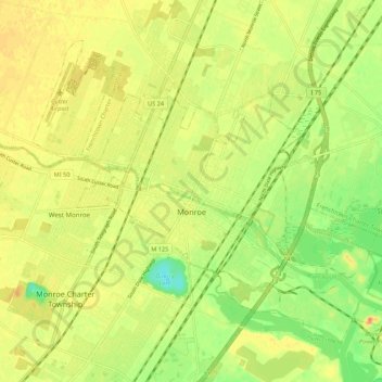
Name: Monroe topographic map, elevation, terrain.
Location: Monroe, Monroe County, Michigan, United States (41.88681 -83.44217 41.95087 -83.33374)
Average elevation: 182 m
Minimum elevation: 157 m
Maximum elevation: 200 m
Make a donation
Gear up for your next adventure:
As an Amazon Associate, this site earns from qualifying purchases at no extra cost to you.
Other topographic maps
Click on a map to view its topography, its elevation and its terrain.
Golfcrest
United States > Michigan > Monroe County > Frenchtown Charter Township
Average elevation: 181 m
River Raisin
United States > Michigan > Monroe County > Raisinville Township > Grape
Average elevation: 192 m
Make a donation
Gear up for your next adventure:
As an Amazon Associate, this site earns from qualifying purchases at no extra cost to you.