
Make a donation
Gear up for your next adventure:
As an Amazon Associate, this site earns from qualifying purchases at no extra cost to you.
Ghebi topographic map
Click on the map to display elevation.
Make a donation
Gear up for your next adventure:
As an Amazon Associate, this site earns from qualifying purchases at no extra cost to you.
About this map
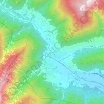
Name: Ghebi topographic map, elevation, terrain.
Average elevation: 1,609 m
Minimum elevation: 1,306 m
Maximum elevation: 2,233 m
Make a donation
Gear up for your next adventure:
As an Amazon Associate, this site earns from qualifying purchases at no extra cost to you.
Other topographic maps
Click on a map to view its topography, its elevation and its terrain.
Tbilisa Glacier
Georgia > Racha-Lechkhumi and Kvemo Svaneti > Oni Municipality
Average elevation: 3,443 m
Buba Glacier
Georgia > Racha-Lechkhumi and Kvemo Svaneti > Oni Municipality
Average elevation: 3,398 m
Make a donation
Gear up for your next adventure:
As an Amazon Associate, this site earns from qualifying purchases at no extra cost to you.