
Make a donation
Gear up for your next adventure:
As an Amazon Associate, this site earns from qualifying purchases at no extra cost to you.
Montgomery topographic map
Click on the map to display elevation.
Make a donation
Gear up for your next adventure:
As an Amazon Associate, this site earns from qualifying purchases at no extra cost to you.
Montgomery
These lands in the west are the lowest-lying in the village. Much of its topography rises gently from the river, with little relief save the Academy Hill area on the east edge of downtown where the village hall is located, and a 455-foot (139 m) hill at the junction of Purple Martin Road and Cardinal Drive that is the highest point in the village, marked by a water tower.
Make a donation
Gear up for your next adventure:
As an Amazon Associate, this site earns from qualifying purchases at no extra cost to you.
About this map
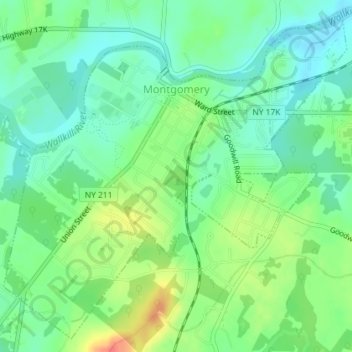
Name: Montgomery topographic map, elevation, terrain.
Average elevation: 118 m
Minimum elevation: 99 m
Maximum elevation: 151 m
Make a donation
Gear up for your next adventure:
As an Amazon Associate, this site earns from qualifying purchases at no extra cost to you.