
Thank you for supporting this site ❤️
Make a donation
Make a donation
Gear up for your next adventure:
As an Amazon Associate, this site earns from qualifying purchases at no extra cost to you.
吉念批 topographic map
Click on the map to display elevation.
Thank you for supporting this site ❤️
Make a donation
Make a donation
Gear up for your next adventure:
As an Amazon Associate, this site earns from qualifying purchases at no extra cost to you.
About this map
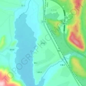
Name: 吉念批 topographic map, elevation, terrain.
Location: 吉念批, Xiaozhongdian, Shangri-La, Diqing, Yunnan, China (27.62943 99.71966 27.66943 99.75966)
Average elevation: 3,282 m
Minimum elevation: 3,220 m
Maximum elevation: 3,488 m
Thank you for supporting this site ❤️
Make a donation
Make a donation
Gear up for your next adventure:
As an Amazon Associate, this site earns from qualifying purchases at no extra cost to you.