Geolocate

Matraia topographic map

Click on the map to display elevation.

About this map

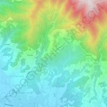
Name: Matraia topographic map, elevation, terrain.

Location: Matraia, Capannori, Lucca, Tuscany, 55014, Italy (43.89262 10.55162 43.93262 10.59162)

Average elevation: 298 m

Minimum elevation: 34 m

Maximum elevation: 957 m

Gear up for your next adventure:

Tent Footprint - Protect tent floor and increase durability
🧭Orienteering Kit - Tools for map reading and navigation in the wild
🏃Hydration Running Vest - Carry water and maps close to your body for speed
🛶Canoe Life Vest - Safety vest for water sports
🧢Hiking Hat - Sun-protective and breathable hats for long treks

As an Amazon Associate, this site earns from qualifying purchases at no extra cost to you.