
Area G (Saltair / Gulf Islands) topographic map
Interactive map
Click on the map to display elevation.
About this map
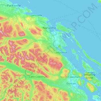
Name: Area G (Saltair / Gulf Islands) topographic map, elevation, terrain.
Average elevation: 282 m
Minimum elevation: 0 m
Maximum elevation: 1,579 m
Other topographic maps
Click on a map to view its topography, its elevation and its terrain.
Thetis Island
Canada > British Columbia > Cowichan Valley Regional District > Area G (Saltair / Gulf Islands) > Spune’luxutth
Thetis Island, Spune’luxutth, Area G (Saltair / Gulf Islands), Cowichan Valley Regional District, British Columbia, Canada
Average elevation: 16 m
Saltair
Canada > British Columbia > Cowichan Valley Regional District > Area G (Saltair / Gulf Islands) > Saltair
Saltair, Area G (Saltair / Gulf Islands), Cowichan Valley Regional District, British Columbia, V9G 2A4, Canada
Average elevation: 66 m