
Make a donation
Gear up for your next adventure:
As an Amazon Associate, this site earns from qualifying purchases at no extra cost to you.
Gräfensteinberg topographic map
Click on the map to display elevation.
Make a donation
Gear up for your next adventure:
As an Amazon Associate, this site earns from qualifying purchases at no extra cost to you.
About this map
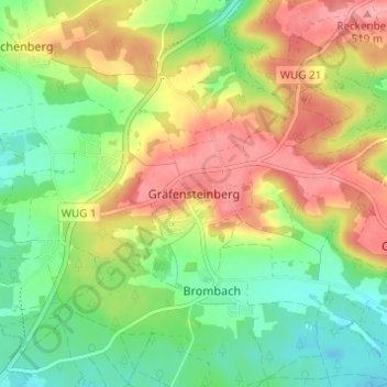
Name: Gräfensteinberg topographic map, elevation, terrain.
Average elevation: 465 m
Minimum elevation: 420 m
Maximum elevation: 520 m
Make a donation
Gear up for your next adventure:
As an Amazon Associate, this site earns from qualifying purchases at no extra cost to you.
Other topographic maps
Click on a map to view its topography, its elevation and its terrain.
Pleinfeld
Germany > Bavaria > Weißenburg-Gunzenhausen
Pleinfeld is situated on the rivers Swabian Rezat and Arbach, 8 kilometres (5.0 mi) north of Weißenburg in Bayern, and 45 kilometres (28 mi) south of Nuremberg. Other rivers in the municipality area are Brombach river and Banzerbach river, both tributary of the Swabian Rezat. The town's altitude is around 382…
Average elevation: 431 m
Make a donation
Gear up for your next adventure:
As an Amazon Associate, this site earns from qualifying purchases at no extra cost to you.
Make a donation
Gear up for your next adventure:
As an Amazon Associate, this site earns from qualifying purchases at no extra cost to you.