Geolocate

Simjung topographic map

Click on the map to display elevation.

About this map

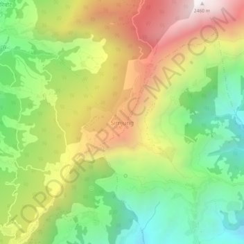
Name: Simjung topographic map, elevation, terrain.

Location: Simjung, Ajirkot, Gorkha, Gandaki Province, Nepal (28.15709 84.64861 28.19709 84.68861)

Average elevation: 1,619 m

Minimum elevation: 957 m

Maximum elevation: 2,453 m

Other topographic maps

Click on a map to view its topography, its elevation and its terrain.

Gorkha

Nepal > Gandaki Province > Gorkha

Average elevation: 787 m

Chum Nubri

Nepal > Gandaki Province > Gorkha

Average elevation: 4,445 m

Chum Nubri

Nepal > Gandaki Province > Gorkha

Average elevation: 4,445 m

Gear up for your next adventure:

💡LED Camping Lantern - Illuminate your campsite with long-lasting lanterns
🧼Travel Hand Sanitizer - Keep hands clean when water is scarce
🥾Waterproof Hiking Shoes - Durable shoes for wet and rugged trails
🧥Waterproof Hiking Jacket - Protect yourself from rain and wind while hiking
🏃Hydration Running Vest - Carry water and maps close to your body for speed

As an Amazon Associate, this site earns from qualifying purchases at no extra cost to you.